Re-reading Geography – Week 6

This week’s readings:


  • Christina Elizabeth Dando, “The Map Proves It”: Map Use by the American Woman Suffrage Movement
  • Craig Dalton and Liz Mason-Deese, Counter(Mapping) Actions: Mapping as Militant Research
  • Rhiannon Firth, Critical cartography as anarchist pedagogy? Ideas for praxis inspired by the 56a inforshop map archive
  • Sebastian Cobarrubias and John Pickles, Spacing movements: The turn to cartographies and mapping practices in contemporary social movements

Cobarrubias and Pickles set the tone for this week’s papers. They note that a range of studies in the critical geography literature have moved beyond deconstructing  maps toward surveying the spatialities of social movements,  and the way social movements themselves think and engage spatially.

Cartography in the service of emancipatory politics is cartography that rearticulates spatial imaginaries in a way that contests ‘common sense’ notions of space and challenges contemporary power relations.

If conventional maps seek to render us objects visible to the control of state, corporate, or imperial power, then cartography of this kind allows us to become subjects mapping out the dynamics of such power by rendering it visible, and malleable, to collective political action. It allows us to lay a finger on the otherwise insidious and ‘invisible’ networks of power that permeate the globe and mask its real inequalities. It affords new ways of understanding our place in the world by exposing forms of enclosure, dispossession, division, and exclusion which challenge globalist arguments that suggest we are heading toward a more prosperous, integrated, and ‘flattened’ future.

They mention two examples of critical cartographic projects that have achieved just that. One was by the Bureau d’Etudes which focussed its efforts on the European Union (EU).  It drew attention to the messiness of the EU project, whose cross-cutting flows of transnational capital, regulatory institutions, legal norms, think tanks, and activist networks belie notions that corporations and governments are the only relevant actors reproducing the EU as a contested space.

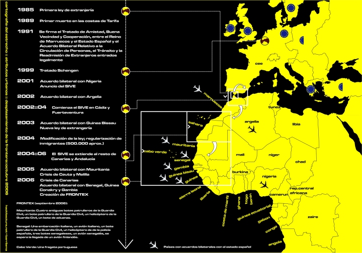
Hackitectura, on the other hand, consists of networks of refugees and their advocates, who have set for themselves the task of “deleting the borders of fortress Europe”. Hackitectivists contest the militarization of the Spanish-Moroccan border, chipping away at the racialised divides that set Europe apart from its African or Asian Other.

07_2006_diagrama_desplazamiento_fro

Using Hackitectura and other examples in the critical GIS literature as starting points, Dalton and Mason-Deese mention the experiences of the Counter Cartographies Collective (3Cs) at the University of Carolina-Chapel Hill in their discussion of “autonomous cartography”.

Autonomous cartography unhinges official narratives that territorialize borders as fixed and impermeable, reterritorializing in its place a vision for spatial justice which seeks answers to the question, as Doreen Massey once put it, of how we might live together. This is a cartography that spells the difference between mapping what is, and mapping what can otherwise be.  It is in the very process of mapping other-possible-worlds that the tyranny of no alternatives can be transcended.

Dando’s article focuses on a more historical example in the American women’s suffrage movement.

At a time when maps as communicative devices were increasingly entering into the public consciousness as a ‘legitimate’ media of truth, suffragists reappropriated their symbolic power – one that gestured toward truth and scientific authority in the eyes of the American public –  in the struggle for women’s right to the vote.

While these efforts did result in the expansion of women’s rights and the inclusion of ‘gender’ as a distinctive right expressed in spatial terms, tensions within the suffrage movement hinged  on its failure  to surmount the white|black  racial binary, and broader class divides that at times alienated the middle-class leadership of the women’s movement from working class voters.

This was clearly the case in a map produced by the Austin Woman Suffrage Association (AWSA) in 1913, which drew on white symbolism and at least implicitly fought for the right of white women to vote to ensure a higher proportion of white voters in the United States:

suffrage.png

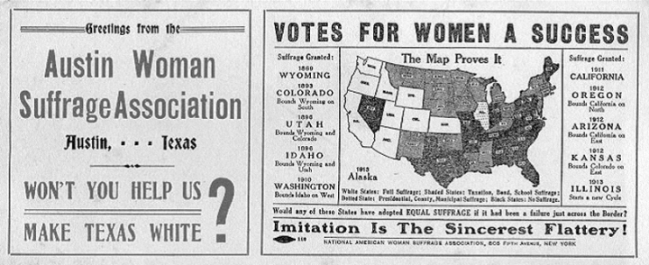
The suffragists were compelled, for pragmatic reasons or otherwise, to negotiate their rights on the terms of a racialised state, and in a language of colour that they felt would legitimate their claims.

The article concludes with the words of feminist activist Audre Lorde which challenge even attempts at ‘critical’ cartography: “for the master’s tools will never dismantle the master’s house.  They may allow us to temporarily beat him at his own game, but they will never enable us to bring about genuine change”.

Indeed it is this which Firth emphasizes in her discussion of affinities between critical cartography and anarchist theory, which both proceed from the assumption that maps are not value-neutral devices. Instead cartographic ‘truth’ is created, as opposed to a ‘reality’ captured and measured through relative degrees of scientific accuracy.  Distinguishing what is scientific from what is not is itself a function of power. But so is the compulsion to negotiate truth claims in the language of ‘oppressive’ power structures.

For instance, well-meaning counter-cartographic projects like those mobilised by advocates of indigenous peoples’ land rights tend still to negotiate their claims within the parameters acceptable to state institutions and corporations. While no doubt useful for the purposes of negotiating rights for the marginalised, even these tend to reinforce the legitimacy of existing institutions while diluting their own radical potential.

Moreover counter-hegemonic mapping typical of Marxist-inspired projects, or movements like the AWSA, rely on singular truth claims that silence other voices while hardening divisions between oppressor|oppressed.  By using the instruments of the oppressor to gain legitimacy, these are simultaneously translated into hegemonic logics, instead of opening space/s for a dialogical encounter between both, and forwarding  new forms of legitimacy for other ways of being in the world.

Anti-hegemony, by contrast, rejects the terms of power, attempting instead to shift the very parameters of debate, through different ways of engaging and transcending regimes of power in the “here-and-now”. It relies on alter-epistemologies that emphasize the role of affect and emotion as alternative cartographic logics.

Firth further argues that discussions of critical cartography in the academic literature tend to be theory-heavy without much interlude into how real social movements operationalize its assumptions in the realm of praxis.   She takes as an example the 56a infoshop, an anarchist collective that started out as a food cooperative in South London.  A 2005 map festival was what started the infoshop’s backroom map archives: a collection of alter-geopolitical maps, affective maps, collective walks and ‘radical history trails’ –  juxtaposed to regular maps –  that invoke visions for real utopias.

Re-reading Geography – Week 3

This week’s readings

  • David Pinder, Mapping Worlds
  • Denis Wood, Maps Blossom in the Springtime of the State
  • Mark Monmonier, Maps, Votes, and Power
  • Thongchai Winichakul, The Coming of a New Geography

Winichakul takes us through the evolution of geography as a discipline in the Kingdom of Siam (Thailand today), the result of creative encounters between East and West, or as he puts it rather poetically, “the rendezvous of indigenous astrology and Western astronomy, as well as everything in the spectrum in between” (p. 46).

The actions of Siamese nobleman Thipakorawong and Mongkut’s challenge to the court astrologers of his re-enact tensions between science and religious tradition in Western Europe. Indeed they remind one of attempts by late-Medieval European scholars to reconcile new scientific understandings of the universe with their theological convictions – resulting in various forms of deism – if only to justify them to a religious public still beholden to the rigid orthodoxies of the Catholic Church.

Even more interesting is Winichakul’s focus on the transition from indigenous to “modern” understandings of space, which only underscores the fact that maps do more than represent reality. They actively shape reality by shaping the very terms by which we imagine the nation – in this case, the “geo-body of Siam”. To imagine a nation on a contemporary map is to associate a country with fixed boundaries, a state, and rules that govern the international system.

Denis Wood picks up on this theme by pointing out that by describing maps as actual representations of reality, there is a tendency to naturalize them, and therefore to obscure the social relations that necessitate the production and use of maps. Wood emphasizes that maps are a relatively recent invention bound to state power rather than originating in a ‘natural’ human tendency to put place on paper.
With the rise of new mapping technologies, and the increasing confidence with which they are being used by a growing number of people, it seems the possibility exists to subvert the mapping monopoly of the “experts”, and for both the purposes and techniques of cartography to be placed in the hands of the wider public.

Similarly, David Pinder argues that maps almost always fulfil an ideological function; that is, they function in the service of specific interests at specific times.   Deconstruction is especially useful in unpicking the truths established by maps, by reading them as texts – analysing their authorship, relationship to other texts, signs and symbols that together form their unique rhetoric.  Pinder also draws on situationist thinking, inspired in part by Debord and Lefebvre, to underscore the performativity of maps and to complicate interpretations of maps as simply tools of power (or alternatively, ‘resistance’).

Monmonier takes the case of the redistricting of New York city to illustrate the intersections between   votes, legislation, power, and cartography. This could certainly be applicable to LGU politics in the Philippines, where voting populations – determined by the jurisdictional scope of municipalities and cities – figure highly in decisions by local political dynasties and national parties during election season.

Re-reading Geography – Week 2

This week’s readings

  • John Krygier and Denis Wood, Ce n’est pas le monde
  • Morton Gulak et al., Mental Mapping in the Richmond Region: The Use of the Physical Environment in Building Regional Cooperation
  • Lewis Robinson, The varied “mental maps” our students have

Krygier and Wood offer an interesting discussion on the nature of maps through a comic book chapter. They conclude that from representing reality, in all senses of the word, maps are propositions that make claims about reality, and can only ever capture aspects of that reality. By emphasizing certain aspects of space over others (i.e. counting the number of malls as an estimate of urban economic growth at the exclusion of other possible interpretations of city space – like the informal economy of slums), maps essentially create reality, and depend significantly upon the map-maker’s purpose or starting assumptions.

A comic book is an interesting, clever way of clearly and simply outlining key debates around what maps are – one that is itself a kind of representation.

Robinson expands on our understanding of representation in an article that delves into our “mental maps” of the world. Drawing on his experiences teaching geography courses at the University of British Columbia,   Robinson tests his students’ preconceptions of what the world, within and beyond Canada’s borders, looks like.  He discovers that map-making is an act of communication, one laden by our political assumptions of how the world ought to look like.

A chapter from Ellard’s book[1] deepens this analysis of mental maps, tracing our cognitive images of borders and nation-states to our imaginaries of everyday lived space – i.e., “the cartography of our own inner mental spaces”. He traces our contemporary cartographic perspectives to the human species’ – often clumsy – attempts to render geographic space legible.

In contrast to last week’s readings which sought to connect our (“modernist”, “abstract”, “reductionist”) mapping practices to historical transformations in modernity, Ellard sees our propensity to make maps as something innate to the species – for instance, drawing on Yi Fu-Tuan to argue that our upright posture has to do with our preference for straight, vertical and horizontal lines with which we construct our maps.   This has at times made it difficult for us to accurately map out the world in all its oblique or muddled complexity.

Finally, in Gulak et al. urban planners were tasked to draw a map of the Richmond Region, Virginia in an attempt to test the “imageabilty” of roads, state boundaries, key historic sites, among other factors of apparent relevance to the individuals involved. Their work has implications for the use of mental mapping as a research methodology as well as an instrument for land use planning to improve conservation efforts, tourism, heritage site restoration, and regional economic cooperation.

[1] Colin Ellard, You are Here: Why We Can Find Our Way to the Moon But Get Lost in the Mall

Re-reading Geography- Week 1

This is the first of a series of weekly reflections on readings from our class with Dr. Joseph Palis, Cultures of Mapping and Counter-Cartographies (Geog 292). 

[Will try to do this more ofen. Since I promised myself I’d do more  »geography » with this blog =P].

This week’s readings

  • Michael Curry, Toward a Geography of a World without Maps: Lessons from Ptolemy and Postal Codes
  • Miles Ogborn, Knowledge is Power: Using Archival Research to Interpret State Formation
  • B. Harley, Maps, Knowledge, and Power

Drawing on language as an analogy for cartography, Harley contests the positivist ethos that assesses maps according to their “accuracy or inaccuracy” in the degree to which they reflect or represent the “real” world. Maps, he points out, in fact construct that world. Maps are actively political images that communicate ideological messages, often in the service of the powerful – legitimising empires, buttressing the territorial pretensions of nation-states, commodifying and enclosing common land, and asserting the supremacy of private property (or corporate) rights.  And they do so under the guise of “disinterested science”. If knowledge is a form of power, such power derives from presenting itself as value-neutral, depoliticised truth.

Maps also function by rendering invisible that which power seeks to control (or cannot control), in a form of othering that reflects right back on the humanity of the map-maker.   The “hidden silences” or unspoken political assumptions of 18th-19th century maps in particular attempted to reinforce the divide between the European self and the Barbarian, black/Asian other,  paradoxically rendering bare the West’s own barbarous colonial conquests.

Harley concludes by emphasising the extent to which cartographic discourse and imperial ideology are linked. Maps have throughout history largely been a “a tool for power not protest” (pp. 301) – at least until now.

For Ogborn, the production of geographic knowledge is vital to state formation. By studying the archival practices of states – the systematic collection of information about populations and territories – we can understand the nature of the state and its organisation of power over space. In my current work on the Bangsamoro peace process, I have attempted to trace the way contemporary discourses around resource control and population management resonate with colonial narratives and state practices in Mindanao’s past. One recognises this process of state construction, for instance, in the discursive production of ethnic groups whose populations were labelled, categorised, and somewhat arbitrarily imposed and deemed representative of specific parts of Mindanao by American colonial authorities. Today, the consolidation of a distinct Moro (indigenous-nationalist), Lumad, or Christian identity is actively used to claim rights over specific districts and municipalities to be covered under the Bangsamoro autonomous region.

Curry, on the other hand, problematizes concepts of topography, chorography, geography, and spatialiaty, which tend to muddle the distinctions between space and place. He argues that discourses of space and place only truly came to our attention with the emergence of the appropriate technologies (maps, data processing capabilities) which, while complicating things further on the scholarly front, are stimulating the production of new forms of data, and ways of interpreting them.

– CJ Chanco